The proposed structure is a 120 foot stealth flagpole communications tower designed to have the appearance of a single tapered pole with no existing appurtenances and will resemble a sailboat mast. The exterior will be white in color and internally house the related transmission cables and antennas. Taken from Dynamic Tower, Inc. Drawing Sheet C-1 and their project description.
Tower height is 120 feet
Tower diameter is 6 or 8 feet (plot drawing reduced in scale so number was not readable.)
Accessory ground equipment will be housed within an existing building.
If a flag is raised on this tower (denied by DTI at March 5, 2015 Local Planning Agency meeting) Federal law requires a flag which is not raised at dawn and lowered at sunset to be lighted throughout the night.
No navigation light will be required (see below)
FEDERAL AVIATION ADMINISTRATION STUDY
The FAA website provides a screening tool for determining whether a proposed structure may be a hazard to navigation and whether it needs to formally be reviewed by the FAA.
https://oeaaa.faa.gov/oeaaa/external/gisTools/gisAction.jsp?action=showNoNoticeRequiredToolForm
When the above referenced latitude and longitude coordinates from the Sailfish Marina as well as the height of the land and the height of the tower are entered into the screening tool, you will then see that this tower is sited within an instrument approach area to Martin County's Witham Airport by 38 feet. The tool presents a drawing of the instrument approach area, and shows where the tower is situated, relative to the airport and states a study is needed.
FEDERAL AVIATION ADMINISTRATION STUDY DETERMINATION
On March 3, 2015 the Federal Aviation Administration (FAA) issued a letter to Dynamic Towers, Inc. of Port St. Lucie (construction firm) stating that their FAA Aeronautical Study No. 2014-ASO-14030-OE for the proposed structure as described with a Latitude of 27-09-40.20N NAD 83 and a Longitude of 80-11-45.20W does not exceed obstruction standards and would not be a hazard to air navigation.
The study states marking and lighting are not necessary for aviation safety.
WHO WILL SEE THIS TOWER?
Only property owners within 300 ft. of the zoning change were notified that this proposal was going before the Martin County Local Planning Agency (notification process flawed see upcoming post). This is completely inadequate for a tower of this height, diameter, and color. Homes in Mariner Cay, the Yacht and Country Club of Stuart, surrounding streets, and a significant number of homes across Manatee Pocket in Rocky Point will have this massive structure negatively impacting their quality of life through noise pollution, light pollution, and sheer ugliness.
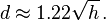
When you take the above description of the tower and use the following formula to calculate the distance from which the tower will be seen, this massive tower will be visible 13.36 miles away.
With d in miles[6] and h in feet,
WHO WILL HEAR THE EQUIPMENT FROM THIS TOWER?
Cell towers require all manner of electrical equipment including cooling equipment which must run 24 hours a day. While the equipment will be housed in a building, it will generate a substantial amount of noise that will be heard in the surrounding neighborhoods and across Manatee Pocket in Rocky Point.
No comments:
Post a Comment
Note: Only a member of this blog may post a comment.